|
Exaggerated For the Book of Mormon, Came to Pass By W. Vincent Coon |
|
|
|
|
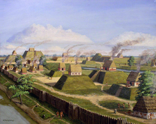
The Art of Herb Roe,
depicting a North American
mound builder city
|
Various "Book of Mormon Geography" theories are depicted in maps
containing two-dimensional information only. The Book of Mormon
actually contains three-dimensional facts about its sacred lands.
It is not enough to find a "narrow neck of land", and a northward flowing river
somewhere in the The directions to various bodies of water, called seas, need to fit scriptural coordinates. Israelite directions depend on the perceived movements of the sun and the moon. (Genesis 1:14) Israelite directions were an integral part of priesthood ordinances. (Leviticus 1:11)
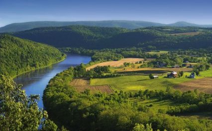
The relative locations and elevations of Book of Mormon lands are
indicated in the text with perfect consistency. Notwithstanding a great
upheaval at the Savior's death, key land features like the "narrow pass", and
the general southward rise
in
elevation persisted.
(Mormon 1:10;
2:29;
3:7-8,
14-16;
4:1) Traveling south
from the
The Book of Mormon narrative describes a limited geography, with prophetic and
historical events associated with it: The book describes a Promised Land that would see Gentile
explorers, pilgrims, the American struggle for
Other non-hemispheric
settings situate Book of Mormon places and events within the mainland of the |
|
What is a common presumption in
all exaggerated settings for the Book of Mormon?
"Now the more idle part of the Lamanites lived in the wilderness, and
dwelt in tents; and they were spread through the wilderness on the west,
in the land of Nephi; yea, and also on the west of the land of
Zarahemla, in the borders by the seashore, and on the west in the
land of Nephi, in the place of their fathers' first inheritance, and
thus bordering along by the seashore." To allege that the north, south, east, and west seas bordering various Book of Mormon lands are all oceanic bodies is to make extrapolations beyond what the scripture says. (Helaman 3:8) The logic that sea must mean ocean, fails in the case of many biblical verses that refer to a "sea" or "the sea" (Numbers 34:11, Joel 2:20) Even "the great sea" (the Mediterranean, Numbers 34:6) bordering the biblical Promise Land, is really an inland body of water.
References to "beach" or "sea shore" in scripture needn't mean an
ocean coast. (Genesis 22:17)
The same Hebrew word "saphah" (שׇׂפׇה) translated "shore" in one instance is also
translated "bank" as in "bank of the Jordan".
(2 Kings 2:13;
The New Brown-Driver-Briggs-Gesenius Hebrew-Aramaic Lexicon,
entry 8193,
שׇׂפׇה, pp. 973-974) The women of the company had given birth during their wilderness sojourn. (1 Nephi 17:1-2) The company could easily have consisted of more than thirty souls at the time they set sail. They had limited stowage. The preferred sea path to the Promised Land would have been one that would keep them in reach of coastline (food and much needed freshwater) for most of the voyage.
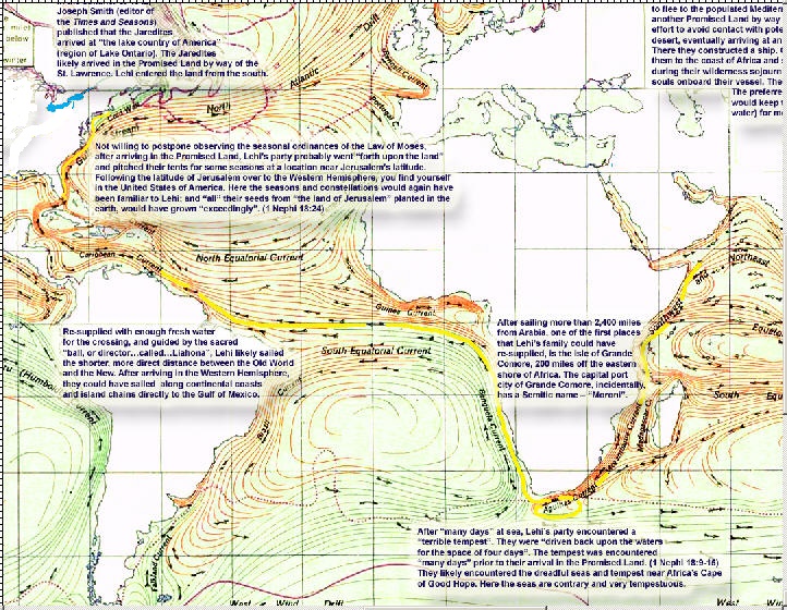
One possible
location where they may have re-supplied is the island of Grande Comore;
about 200 miles off the eastern coast of Africa. The capitol port city
of the island, by the way, has the Book of Mormon sounding name – "Moroni".
Thus Book of Mormon immigrants to the New World didn't just sail across the many waters to the
land of promise, they sailed "cross the large waters
into
the promised land..." as the scripture says.
(1 Nephi summary,
Omni 1:16)
The spiritual significance of taking a
strait and narrow course across a gulf was not lost on later generations
of Lehi's faithful descendents. (Helaman 3:29)
Scripture indicates that Lehi's family traveled so far northward that
they encountered, "driven snow" a description used by Nephi in relating
details of his vision to future generations of his people
in the American land of promise.
(1 Nephi 11:8) A company the size of Lehi's must have required many stops along the way - for freshwater and victuals if nothing more. These necessary landfalls were not recorded in the abridgement. It stands to reason that they did not risk bringing the ship too close to shore each time. They likely had smaller craft for these excursions. Smaller craft could have also aided in bringing Lehi's company to their inheritance near Lake Erie. Jacob son of Lehi referred to the land they arrived at as "an isle of the sea", an expression he took from Hebrew scripture. (2 Nephi 10:20-21) The Hebrew word translate "isle", "i" (אִי) means "coast", "region", "habitable land". It does not exclusively mean an island or small landmass entirely surrounded by water. Isaiah in fact, uses the same Hebrew word to describe Mediterranean countries, including the land of Israel. (Isaiah 20:6; The New Brown-Driver-Briggs-Gesenius Hebrew-Aramaic Lexicon, entry 339, אִי, pp. 15-16) Certain Book of Mormon lands "were nearly surrounded by water..." (Alma 22:32), but the "water" mentioned does not have to mean ocean.
Crossing "the large waters into the promised land..." (1 Nephi 1)
Both May and Olive agree that other ancient peoples in the Book of
Mormon land northward (the Jaredites and the Mulekites), arrived by way
of the Atlantic and St. Lawrence channel. This opinion agrees with
Joseph Smith's statement, placing the arrival of the Jaredites in the
region of "the lake country of America" (near Lake Ontario).
("Traits of the Mosaic History Found Among the
Aztaeca Nations", Times and Seasons, June 15, 1842, Vol. 3, No. 16, pp
818-20, signed with Joseph Smith's "ED") Josiah Priest, whose
written work Joseph Smith editorialized, associated the title
"lake country" with the Great Lakes region of America. [5] |
|
|
|
How did the mistake of placing Zarahemla so very far from Cumorah come
about?
Orson Pratt
outlived more than one Apostle who differed with his geographic conclusions.
Late in the nineteenth Century, Orson Pratt’s geography prevailed to the point
of being published as footnotes in the 1879 edition of the Book of Mormon.
Though his speculative footnotes have since been removed, his influence carries
on in the Church. Elder Orson Pratt started promoting his over-sized
Book of Mormon geography as a brilliant young missionary on fire with
his own vision of the scripture - a book which he had only begun to
study in depth.
Elder Pratt discoursed on “ancient” Cumorah in western Out of line with key Book of Mormon details, Elder Pratt
placed Nephite cities like “Amonihah in the northern part of South
America”,
while correctly recognizing Cumorah in western
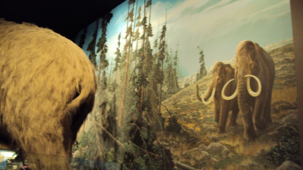
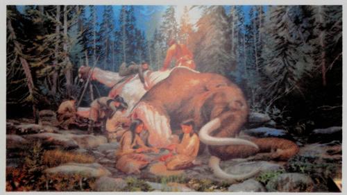
Murals at the Rochester Museum
of Science depicting the prehistoric New York mastodon and its use by local
people. Large numbers of these creatures inhabited western New York in ages
past. The discovery of
mastodon remains in New York, where native earthworks were also found, led many to
presume that the animal was contemporary
with mound building people. (Ether 9:19) Latter-day Saint Apostle Orson Pratt
acknowledged the mound builder
setting for the Book of Mormon, but exaggerated it. Elder Pratt stretched his
mound builder geography
over
the Western Hemisphere! His geographic views greatly influenced Mormon
opinion for a while.
American Heartland
e.g.
”Manti” in Missouri, circa 1838, as indicated in the
Journal of Samuel D. Tyler, September 25, 1838. In the late 1830s,
some members of the Church claimed that the Book of Mormon city of Thus we see that the hemispheric setting was not the only geographic model on the minds of early members of the Church. Joseph Smith’s contemporaries had different, conflicting ideas about Book of Mormon lands. Joseph apparently tolerated this, but he refused to take responsibility for things published in his name, that did not come under his supervisions. For instance in the March the 1842 issue of the Times and Seasons, Joseph refused to take responsibility for the previous February 15 issue published in his name. The absence of certified comments from Joseph Smith on ideas of the time like: Manti in Missouri, Lehi’s landing in Chile, Lehi’s landing just south of Panama, "the narrow neck of land" embracing all of Central America, Zarahemla at Quirigua, etc., does not mean that he endorsed these conflicting ideas. Joseph at the very least had resolved that some Book of Mormon events took place in his own country. He clearly stated this, and the Saints accepted it! Beyond this he apparently allowed the Saints to do as the Bible directs: “…consider of it, take advice, and speak your minds.” (Judges 19:30)
Even though exaggerated hemispheric settings for the Book of Mormon were
encouraged by some early Church leaders, there is no known statement by Joseph
Smith endorsing a hemispheric model.
The fact that Elder John Page entertained a non-hemispheric setting
for the Book of Mormon, indicates that Joseph Smith did not teach a hemispheric
setting as an oral tradition. Page clearly did not agree with the geography of his contemporary Orson Pratt (who did not attribute his
hemispheric model to Joseph Smith or to revelation). [8] The fact
that other LDS in the late 1830s placed southern Nephite territory (Manti) in
the
The Hemispheric geography got a boost sometime after the death of Joseph Smith, when the Williams document (alleging
a While having "no confidence" in various Book of Mormon geographies of his day, First Presidency member George Q. Cannon nevertheless regarded the location of Cumorah as settled. [11] The thing that all early models agreed on was the general location of the land Cumorah revealed by Joseph Smith. (D&C 128:20) In time, the RLDS church relegated Joseph Smith’s epistle mentioning Cumorah, to an historical appendix in their version of “the Doctrine and Covenants” (RLDS D&C 110; see also RLDS D&C 107), even though the Prophet had endorsed the epistle as “the word of the Lord”. (LDS D&C 127:10, D&C 128:1-2) The chief subject of the epistle is “baptism for the dead”, a practice RLDS leaders chose not to regard as binding upon their following. Marginalizing the authority of Joseph’s epistle on baptism for the dead made dismissing the location of Cumorah indicated in the epistle, less problematic for RLDS members. It is not surprising, therefore, that the earliest "limited" Central American geography theories, dismissing the revealed location of Cumorah, were advanced by RLDS.
To be fair, RLDS
should be recognized for their
attention to some Book of Mormon details. Some
began to realize that the book’s principal lands were more
localized than previously supposed.
(Hills, Louis E., 1917; Gunsolley, Jeremiah F., 1922) [9] Even so, a decision was made to
shrink-fit proposed settings around distant locations that had been
celebrated in
exaggerated geographies, and travelogues instead of anchoring near the land Cumorah
revealed by Joseph Smith. In other words, some chose to trade the
location of
Cumorah revealed by the Prophet, for exotic pottage in
faraway places! But none of these misplaced “limited geographies” are
truly limited in one important detail: They all have
In the Book of Mormon land northward, even before the abridgement of the
record was complete, the Lord commanded
It wasn’t that there were no candidates for a “narrow neck of land” right there
in the vicinity of the Great Lakes, not far from Cumorah and the Smith
home; or a river flowing northward in the same region, qualifying as “Sidon”. It
wasn’t for lack of finds like mounds of earth, timber breastworks, old
copper artifacts; and stories of great battles between long ago peoples of the
region. Rather it was that Latter-day Saints, a persecuted people, turned to
popular works for support - works like Stephens'
bestseller, rather than remembering to
consider in detail, the “New Covenant, even the Book of Mormon”. This is
essentially how unauthentic traditions and a mass of confusion, regarding the
book’s covenant lands, came about. The general Finger Lake’s location of the Book of
Mormon land Cumorah is of course consistent
with the original "Mound-builder" setting. American historian and
journalist Hampton Sides is incredulous towards the proposal of an
alternate Cumorah. Sides remarks, “As fantastic as
it may seem, Sorenson actually argues that there were two Cumorahs: one in Mexico where the great battle took
place, and where Moroni buried a longer, unexpurgated version of the
golden Nephite records; and one near Palmyra, New York, where Moroni
eventually buried a condensed version of the plates after lugging them
on an epic trek of several thousand miles…”
(Sides,
Today, there is no question in the minds of American History and Literature
scholars as to the Book of Mormon’s legitimate setting. These scholars are not
distracted by unauthentic traditions and misadventures that still intoxicate
and
befuddle
the minds of so
many Mormons (LDS and "Community of Christ"). American History scholars go straight to the best sources; which
include, Latter-day Saint scripture and verifiable statements by Joseph Smith.
Uncertainty about the location of Lehi’s covenant land of liberty remains a
uniquely "Mormon" problem. But with improving
attention to scripture, more Latter-day Saints are coming to recognize authentic lands
of the Book of Mormon
with a devotion akin to what others have felt all along for another Promised Land.
“If I forget thee, O Jerusalem, let my right hand forget her cunning.”
(Psalm 137:5)
|
|
|
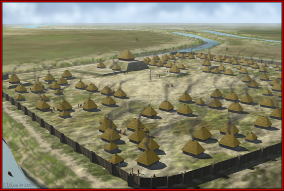
The Art of Herb Roe, depicting a mound builder city of earth, timber and plaster-like "cement"
|
Additional References:
[1]
Silverberg, Robert,
“…and the mound-builders vanished from the earth”
, American
[2]
May, Wayne N., This Land, They Came from the EAST, Vol. 3, pp.
12-15
[3]
Olive, Phyllis Carol, The Lost Lands of the Book of Mormon, pp.
49-67
[5]
Priest, Josiah, American Antiquities, “Traits of the Mosaic
History found among the
[6]
Stephens, John Lloyd, Incident of Travel in Central America
[7]
Millennial Star, Vol. 16, May 13, 1854, pg. 296
[8]
Journal of Discourses, Vol. 14, pg. 325 [9] Roper, Matthew, “Limited Geography and the Book of Mormon: Historical Antecedents and Early Interpretations”, section titled “Parley P. Pratt’s View”, BYU Maxwell Institute, 2004.
[10]
Richards,
[11] Cannon,
George Q., “Topics of the Times”, Juvenile Instructor, Vol. 22, No, 14,
July 15, [12] Teachings of the Prophet Joseph Smith, Compiled by Joseph Fielding Smith, pg. 267
|